


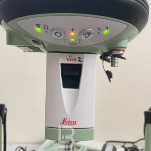
Leica Viva GS14 GNSS RTK Rover is the most compact and powerful GNSS receiver. The integrated mobile communications and UHF modem means it is suited for any measuring task. With its convenient, integrated design, the Leica Viva GS14 GNSS RTK Rover is easy to use. Leica Viva GS14 GNSS RTK Rover together with the leading GNSS RTK the Leica Viva GS14 GNSS RTK Rover meets the highest standards for measurement technology.
Leica Viva GS14 GNSS RTK Rover SmartCheck technology evaluates and verifies your RTK solution to ensure the most reliable RTK measurements. Thanks to SmartCheck Leica Viva GS14 GNSS RTK Roverdelivers the highest reliability possible. The unique SmartCheck technology automatically makes permanent, independent checks while you are working.
Leica Viva GS14 GNSS RTK Rover SmartTrack technology guarantees the most accurate signal tracking. Leica SmartTrack technology is future-proof and ensures compatibility with all GNSS systems today and tomorrow.
Leica Viva GS14 GNSS RTK Rover is Leica Geosystems technology that provides additional, reliable positions in difficult measuring environments. It provides highest availability in even the most difficult conditions at a slightly lower accuracy than a standard RTK fix.
Leica Viva GS14 GNSS RTK Rover Features:
- Leica SmartCheck
- Leica SmartTrack
- Leica xRTK
- Leica Intenna
- Integrated RTK devices
- Onboard RINEX Logging
- Lightweight
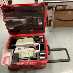
Leica Viva GS14 GNSS RTK Rover Included:
- Leica GS14 GNSS Rover Antenna Receiver [ID- -L/T*]
- Battery Pack
- Battery Charger
- Antenna
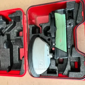
- Carrying Case
You may also be interested in Leica GS18 GNSS RTK Rover
Leica Viva GS14 GNSS RTK Rover Specifications:
| GNSS technology | Leica patented SmartTrack technology: • Advanced measurement engine • Jamming resistant measurements • High precision pulse aperture multipath correlator for pseudorange measurements • Excellent low elevation tracking • Very low noise GNSS carrier phase measurements with <0.5 mm precision • Minimum acquisition time |
| No. of channels | 120 channels (240 channels)3 |
| Max. simultaneous tracked satellites | Up to 60 Satellites simultaneously on two frequencies |
| Satellite signals tracking | • GPS: L1, L2, L2C • GLONASS: L1, L2 • Galileo • BeiDou • SBAS: WAAS, EGNOS, GAGAN, MSAS, QZSS |
| Reacquisition time | < 1 sec |
| Accuracy (rms) Code differential with DGPS / RTCM | |
| DGPS / RTCM | Typically 25 cm (rms) |
| Accuracy (rms) with Real-Time (RTK)1 | |
| Standard of compliance | Compliance with ISO17123-8 |
| Rapid static (phase) Static mode after initialization | Horizontal: 5 mm + 0.5 ppm (rms) Vertical: 10 mm + 0.5 ppm (rms) |
| Kinematic (phase) Moving mode after initialization | Horizontal: 10 mm + 1 ppm (rms) Vertical: 20 mm + 1 ppm (rms) |
| Accuracy (rms) with Post Processing1 | |
| Static (phase) with long observations | Horizontal: 3 mm + 0.1 ppm (rms) Vertical: 3.5 mm + 0.4 ppm (rms) |
| Static and rapid static (phase) | Horizontal: 5 mm + 0.5 ppm (rms) Vertical: 10 mm + 0.5 ppm (rms) |
| Kinematic (phase) | Horizontal: 10 mm + 1 ppm (rms) Vertical: 20 mm + 1 ppm (rms) |
| On the Fly (OTF) Initialization | |
| RTK technology | Leica SmartCheck technology |
| Reliability | Better than 99.99% |
| Time for initalization | Typically 4 sec2 |
| OTF range | up to 70 km2 |
| Network RTK | |
| Supported RTK network solutions | VRS, FKP, iMAX |
| Supported RTK network standards | MAC (Master Auxiliary Concept) approved by RTCM SC 104 |
| Weight (GS14) | 0.93 kg |
| Dimension (GS14) (diameter x height) | 190 mm x 90 mm |
| Environmental specifications | |
| Temperature, operating | –40° C to +65° C, compliance with ISO9022-10-08, ISO9022-11-special, MIL STD 810F – 502.4-II, MIL STD 810F – 501.4-II |
| Temperature, storage | –40° C to +80° C, compliance with ISO9022-10-08, ISO9022-11-special, MIL STD 810F – 502.4-II, MIL STD 810F – 501.4-II |
| Humidity | 100%, compliance with ISO9022-13-06, ISO9022-12-04 and MIL STD 810F – 507.4-1 |
| Proof against: water, sand and dust | IP68 according IEC60529 and MIL STD 810F – 506.4-I, MIL STD 810F – 510.4-I and MIL STD 810F – 512.4-I Protected against blowing rain and dust Protected against temporary submersion into water (max. depth 1,4 m) |
| Vibration | Withstands strong vibration during operating, compliance with ISO9022-36-08 and MIL STD 810F – 514.5-Cat.24 |
| Drops | Withstands 1.0 m drop onto hard surfaces |
| Functional shock | 40 g / 15 to 23 msec, compliance with MIL STD 810F – 516.5-I No loss of lock to satellite signal when used on a pole set-up and submitted to pole bumps up to 100 mm |
| Topple over | Withstands topple over from a 2 m survey pole onto hard surfaces |
| Power & Electrical | |
| Supply voltage | Nominal 12 V DC Range 10.5 – 28 V DC |
| Power consumption | Typically: 2.0 W, 270 mA UHF transmit: 3.3 W, 270 mA |
| Internal power supply | Recharge & removable LI-Ion battery, 2.6 Ah / 7.4 V, 1 battery fit into receiver |
| Internal power supply, operation time | • 10.00 h static observations4 • 7.00 h receiving RTK data with internal UHF radio4 • 5.00 h transmitting RTK data with internal UHF radio4 • 6.00 h receiving / transmitting RTK data with internal modem4 |
| External power supply | Rechargeable external NiMh battery 9 Ah / 12 V |
| Certifications | Compliance to: FCC, CE, PTCRB Local and operator specific approvals (as IC Canada, C-Tick Australia, Japan, China, AT&T) |
| Memory | |
| Memory medium | Removable microSD Card: 1 GB |
| Data capacity | 1 GB is typically sufficient for about GPS & GLONASS (8+4 satellites) 280 days raw data logging at 15 s rate |
| Data recording | |
| Type of data | Onboard recording of: • Leica GNSS raw data • RINEX data |
| Recording rate | Up to 20 Hz |
| Buttons | • ON / OFF button • Function button |
| Button functionality | Function button: • Easy switch between Rover / Base mode • Easy “Here” positioning functionality |
| Led status indicator | Bluetooth®, position, RTK Rover status, RTK Base status, data logging, internal power status, external power status |
| Additional user interface | Additional web interface functionality provides full status indicator and configuration options |
| Communication ports | 1 x USB / RS232 Lemo 1 x Bluetooth® port, Bluetooth® v2.00+ EDR, class 2 |
| Built In data links | |
| Radio modem | • Fully integrated, fully sealed receive and transmit radios • SATEL, Pacific Crest and TrimTalk support • 403 – 473 MHz bandwidth • Output power 1W max. |
| UHF antenna options | • External UHF antenna connector (Type QN) |
| GSM / UMTS phone modem | • Fully integrated, fully sealed phone modem • User exchangeable SIM card • Quad-Band GSM / GPRS: 850 / 900 / 1800 / 1900 MHz • Penta-Band UMTS: 800 / 850 / 900 / 1900 / 2100 MHz |
| GSM / UMTS antenna | • Integrated GSM / UMTS antenna |
| External data links | |
| Radio modems | Support of any suitable UHF / VHF radio |
| GSM / UMTS / CDMA phone modems | Support of any suitable GSM / GPRS / UMTS / CDMA modem |
| Landline phone modems | Support of any suitable Landline phone modem |
| Communication protocols | |
| Real-Time data formats for data transmission and reception | Leica proprietary formats (Leica, Leica 4G) CMR, CMR+ |
| Real-Time data formats according RTCM standard for data transmission and reception | RTCM 2.1, RTCM 2.3, RTCM 3.0, RTCM 3.1 (full support of RTCM 3 Transformation Message) |
| NMEA output | NMEA 0183 V 4.00 and Leica proprietary |


Reviews
There are no reviews yet.